
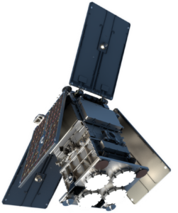
Satellite Platform – HydroGNSS uses the SSTL-21 platform at a size of 45 cm x 45 cm x 70 cm and around 65 kg total mass per satellite. The payload will be operated at near-100% duty, and can support high data download rates using an X-Band transmitter. Star cameras provide precise attitude knowledge, and a xenon propulsion system permits orbit phasing, collision avoidance and supports satellite disposal at the end of the mission. The two HydroGNSS satellites will take a ride-share launch into a 550 km sun-synchronous orbit and phased apart by 180° to maximise coverage.
Payload – The SGR-ReSI-Z, is a Delay Doppler Mapping Receiver tracking the direct GPS and Galileo signals through the zenith antenna and processing the reflected signals from the nadir antenna into Delay Doppler Maps (DDMs). The zenith and nadir antennas use dual frequency all metal patch technology which allows the reception of dual frequency and dual polarised signals. Low Noise Amplifiers include blackbody loads to provide calibration for the amplitude measurement. The DDMs are output at 1 Hz and placed at the correct location through open loop predictions adjusted by an on-board digital elevation model for land height. A higher rate coherent channel is added to permit access to strong reflections at higher spatial resolution on the ground. The SGR-ReSI-Z also supports the short duration collection of unprocessed sampled raw data to allow the test of processing techniques on the ground.
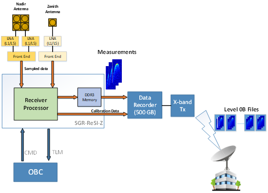
The generated measurement datasets are stored on the satellite’s data recorder and downloaded to ground stations at allocated passes several times per day. The Payload Data Ground Segment (PDGS) processes and archives the data. Level 1 and Level 2 processors provided by science partners generate the Level 1 and Level 2 data, which are made available to users via the file transfer portal, fronted by a web-portal.