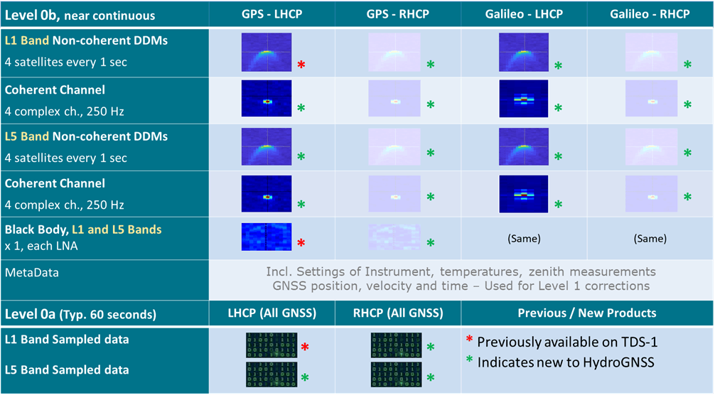
Level 0 Product Summary
Level 1 Product Summary
Level 1 Product | Configuration | About |
|---|---|---|
Delay Doppler Maps | L1/E1 LHCP | Full Delay Doppler Maps for each frequency and polarisation (GPS and Galileo) |
Reflectivity at Specular Point | L1/E1 LHCP | Radiometrically corrected Reflectivity at Specular Point |
Sigma-0 / NBRCS | L1/E1 LHCP | Sigma-0 or Normalised Bistatic Radar Cross Section at Specular Point |
Coherent Coefficient: | L1/E1 LHCP | Coherent coefficient at specular point |
Estimated EIRP at Specular Point | L1/E1 | Effective Isotropic Radiated Power from GNSS satellite towards Specular Point |
Blackbody Noise | L1 band, L5 band | Measured Noise power calculated from nadir and direct blackbody loads |
Geometry, Antenna Gain, SNR, other meta-data | All channels | Meta-data including geolocated specular point, antenna gain, SNR |
Level 2 / Level 3 Product Summary
L2 Processor | Outputs | Grid | L3 Temporal Average | Units / Uncertainty | Validation |
|---|---|---|---|---|---|
L2OP-SSM Soil Moisture | L2G, L3 | 25 km | 1 day | m³/m³ 0.04 | SMAP, SMOS, San Luis Valley, Chad |
L2OP-FT Freeze Thaw | L2G, L3 | 25 km | 5 days rolling | Binary flag 90% | SMAP, SMOS, Sodankylä |
L2OP-SI Surface Inundation | L2 (1 Hz) L2 (25 Hz) | Ungridded | – | Binary flag 90% | JRC GSW |
L2OP-FB Forest Biomass | L2 (1 Hz), L3 | 25 km => 1 km | 6 months | T/Ha 20% | GEOCARBON, Gabon, Sodankylä |
L2OP-SWS Ocean wind & Ice | L2 (1 Hz) | Ungridded | – | m/s 2 m/s, Binary 90% | ASCAT, ERA-5 |
Data formatted in NetCDF, Levels 1 and 2 divided into 6 hour periods. Product Manual will be made available nearer launch.